REFORM newsletter No 1 – June 2012

Welcome editorial by the REFORM Coordinator

Dear reader,

I am pleased to introduce the first REFORM newsletter. REFORM will prepare a newsletter every half year to inform interested people on the progress of our project and on other connected developments. You can subscribe to receive the newsletters automatically. Of course we very much appreciate when you forward our newsletter to other colleagues. At first I wish to introduce the REFORM project briefly to you.

REFORM addresses the 2010 FP7 research call on hydromorphology and ecological objectives of the Water Framework Directive (WFD). After multiple research projects that had a strong emphasis on assessment methods, the request for a new research project moved towards the effectiveness of river restoration and to more cost-effective and precise monitoring to evaluate the impact of hydrological and morphological interventions be it degradation or restoration. REFORM is therefore targeted towards development of guidance and tools to make river restoration and mitigation measures more cost-effective and to support the 2nd and future River Basin Management Plans for the WFD. REFORM will also develop a web-based tool for exchanging experiences with river restoration measures facilitated and enhanced through consultation with stakeholders.

Aims of REFORM are to provide a framework for improving the success of hydromorphological restoration measures and to assess more effectively the state of rivers, floodplains and connected groundwater systems. The restoration framework addresses the relevance of dynamic processes at various spatial and temporal scales, the need for setting end-points, analysis of risks and benefits, integration with other societal demands (e.g. flood protection and water supply). The work is being organized in three modules: (1) natural processes, (2) degradation, (3) restoration and all work packages are multidisciplinary.

Photo: REFORM partners at the kick-off meeting in Florence, Italy, 28 November – 2 December 2011

Photo: REFORM partners at the kick-off meeting in Florence, Italy, 28 November – 2 December 2011.

In this first newsletter you will find an article on the WISER project (www.wiser.eu). WISER already dedicated part of its research to restoration. WISER and FORECASTER (http://forecaster.deltares.nl) were the first two international projects addressing river restoration in Europe. The coordinator of WISER, Daniel Hering, is also a key partner in REFORM giving us the best opportunity to continue with the outcome of WISER.

Our ambition is to interview a key person on river restoration and river studies in Europe for each newsletter. In the first issue Prof. Klement Tockner amongst others editor of the book ‘Rivers in Europe’ and coordinator of the EU-funded BIOFRESH  (www.freshwaterbiodiversity.eu) project is in the spotlight.

In the first newsletter we present two aspects of REFORM: the cross-cutting work package 1 and the case study catchments. Work package 1 compiles and disseminates existing knowledge and expertise on river degradation and restoration in the first phase of REFORM. Case study catchments are one of the key features of REFORM. They assess the interaction between restored stretches and the status of the wider catchment. To prepare the sampling in these catchments, a field training was organised last May in Denmark. An impression of this meeting is presented. Also one of the case studies, the Narew River in Poland, is presented in this newsletter. The Narew River will be the venue for the 2nd all partner meeting of REFORM this coming September, which includes a workshop with local stakeholders to discuss the restoration strategy for this river.

From the very beginning of the project, REFORM partners have been invited to present the project at meetings of the WFD Common Implementation Strategy, at the Working Group F on Floods meeting in Bucharest and at the ECOSTAT hydromorphology meeting in Brussels. The interaction with such working groups is very important, because many studies to assess hydromorphology and ecology of rivers are carried out within Member States. REFORM wishes to connect and support these national research efforts. Short impressions of both meetings are given.

I would like to invite you to visit our website (www.reformrivers.eu), which gives further details on the REFORM project. Once deliverables are ready they will – of course - be uploaded here.

If you have recommendations to improve our website or newsletter, would like to explore the opportunity to cooperate or have questions, do not hesitate to contact me or any of the other REFORM partners.

On behalf of the REFORM team

Tom Buijse

Coordinator REFORM

For further information: 

Author: Tom Buijse

River restoration in need of priorities and a process-oriented approach - An interview with Professor Klement Tockner

Klement Tockner is a full professor for Aquatic Ecology at the Free University Berlin and director of the Leibniz-Institute of Freshwater Ecology and Inland Fisheries (IGB), the largest freshwater ecology institute in Germany (www.igb-berlin.de). He received a PhD at the University of Vienna, and a titulary professorship at ETH. He has special expertise on freshwater biodiversity, ecosystem functioning, and river and wetland restoration and management. He is Editor-in-Chief of the journal Aquatic Sciences and Subject Editor of the journal Ecosystems. He has published more than 180 scientific publications including 100+ ISI papers. At present, he coordinates a large EC-funded project on freshwater biodiversity (www.freshwaterbiodiversity.eu). He is member of several scientific committees including the crosscutting group on freshwater biodiversity of DIVERSITAS. Within REFORM, Professor Klement Tockner and Professor Huib de Vriend (Deltares) are jointly responsible for the internal scientific quality control process.
1. Professor Tockner, what is your affiliation with rivers?

I have worked on river floodplains since the beginning of my career, mostly on large rivers and Alpine streams. During the past 15 years, I have had the great opportunity to study rivers in Africa, the USA, Japan, Australia, and several European countries. These experiences have broadened my view on river system functioning. In particular, I am interested in integrating the hydrogeomorphic, ecological, and social dimensions of river corridors. I have been involved in large river restoration programs where scientists and managers closely cooperated from the beginning on, for the benefit of both.

2. What are the greatest challenges at the moment in restoring rivers in Europe?

The major anthropogenic impacts, and the challenges, differ across Europe. River fragmentation, due to hydropower production, is critical in Northern Europe, pollution in Eastern Europe, channelization in Western Europe, and water scarcity in the Mediterranean area. There are, however, common challenges across the regions:

First, the non-deterioration principle of the WFD must be granted higher priority than the objective of achieving a good ecological status; restoration cannot compensate for the loss of the last free- flowing rivers. We are currently witnessing a rapid loss of the remaining free-flowing and near-natural rivers, for example in the Balkans but also in the Alps.

Second, it will be impossible to achieve good ecological status or even good ecological potential of all modified European rivers within the next 10 to 20 years. Therefore, clear priorities must be set for where restoration should be carried out, which measures are required, and when they should be implemented.

Third, we need to shift to a process-oriented approach in management by integrating geomorphic, hydrological, and ecological functions. Furthermore, we lack long-term data, in particular about the ecological conditions, which limit our ability to assess and forecast trends. A solid database is critical for successful restoration.

3. How can research contribute to addressing these challenges? What do you consider to be the importance of a EU-level project such as REFORM to improve the success of hydromorphological restoration measures?

One way to address these challenges is to focus on the key processes and landscape features. For example, vegetated islands, pivotal landscape elements that were once very common along all European rivers (and still are in many rivers), are among the first elements that disappear as a consequence of river and flow regulation. Remaining vegetated islands are usually in a more natural state than adjacent riparian areas, forming “nuclei” for restoration and conservation. However, the formation of vegetated islands requires space, a dynamic flow regime, and sediment and large wood supply. Another approach is to focus on succession processes. Biodiversity depends on a full range of succession stages, from bare gravel to mature forests. Research projects like REFORM can deliver good practice examples as well as a network of large restoration sites in order to establish the links between lessons learned from science and lessons learned from practice.

Photo: Artificial riffles in the Belgian - Dutch border stretch of the River Meuse were recently created to maintain groundwater levels in the adjacent Natura 2000 areas and enlarge local habitat diversity in the main channel

4. You are the coordinator of the EU-funded project BioFresh on freshwater biodiversity. Do you see commonalities between BioFresh and REFORM and ways for the two projects to connect?

These are highly complementary projects. BioFresh, which runs until April 2014, focuses on freshwater biodiversity (i.e. the response side), while REFORM´s focus is more on fluvial geomorphic aspects (i.e. the stressor side). In this sense, BioFresh and REFORM form a bridge connecting drivers and responses.

REFORM can benefit from the publicly available database that BioFresh is building. The compilation of a European biodiversity database allows the identification of priority areas for management. Such a tool is also required for the key stressors. Combining both databases would allow to identify areas that have the highest conservation value and restoration potential.

Additionally, BioFresh will produce an interactive Global Freshwater Biodiversity Atlas which might serve as a major information source for REFORM too.

5. How important is it for REFORM to be integrated in relevant (research) networks within Europe and beyond? To whom should REFORM connect to as priority?

In Europe, REFORM needs to connect to the implementation of the WFD, the Habitats and the Flood Directives, and to Sednet (the European Sediment Network). At the global scale, REFORM should explore links with GEO BON (Group on Earth Observations) and the Global Water System Project.

Among the great challenges in the water sector is the development of synergies among the currently competing objectives in agriculture, navigation, industry, and ecology. The discussion on the water-energy-food nexus must integrate waters as ecosystems too. Ecosystem services are currently used in a very narrow, simplified approach, purely from a human use perspective. Therefore, it remains a major challenge to manage rivers not just for the optimization of a few services but to consider intrinsic values and ethical aspects too. Otherwise, we will lose most of the rich biodiversity of rivers and floodplains within the coming decades.

6. What do you believe should be done to support the achievement of WFD objectives with regard to hydromorphology more effectively?

Despite major merits, there are limitations to the concept of the WFD:

First, using past reference conditions as a goal for future ecosystem management under rapidly changing environmental conditions is disputable. The question will not be “which organisms lived in a specific system”, but “which can live in the system”. Novel communities, a combination of native and non native assemblages that have no shared history, will dominate future ecosystems. We need to understand how novel assemblages form, what their ecological and economic consequences are, and how they should be managed.

Second, the WFD is based on a rather static view of rivers; a process-oriented approach is required for their future management.

Third, many restoration projects fail because they mainly focus on the channel but underestimate the functional linkages with the terrestrial and subsurface realms. Aquatic insects, for example, exhibit a higher mortality during the short terrestrial phase - when they emerge, disperse and mate - than during the larval stage. However, we have scant information about the various habitat requirements of organisms that have complex life cycles.

Last but not least, restoration efforts – in particular for heavily modified water bodies - will need to be complemented by, or perhaps even replaced by, increasing levels of management intervention, in order to create and maintain the desired ecological values of ecosystems. This includes the manipulation of the hydrology, the construction of artificial habitats, as well as combining technical with more natural systems.

Professor Tockner was interviewed by Eleftheria Kampa (Leader of Dissemination and Stakeholder Involvement of REFORM, Ecologic Institute) on 7 June 2012 in Berlin.


For further information: 

Author: Eleftheria Kampa
Klement Tockner

The WISER project – Key results

WISER was a large EU-funded research project, which was finalized in February 2012. The acronym WISER stands for “Water bodies in Europe – Integrative Systems to assess Ecological Status and Recovery”. Similarly to REFORM, WISER supported the implementation of European policies in the field of environmental protection, in particular the Water Framework Directive (WFD). While REFORM is focusing on rivers and hydromorphology, WISER mainly dealt with lakes and marine ecosystems (to a lesser degree with rivers) and addressing both assessment and restoration.

Many of the WISER results, however, are of relevance for REFORM. Amongst other, WISER produced a large database with biological assessment methods applied by the European countries to judge the quality of their water bodies – more than 300 methods are presently in use, and more than a quarter of the methods aim amongst others to assess the effects of hydromorphological degradation on the biota (http://www.wiser.eu/results/method-database/).

A main part of WISER addressed the development and intercalibration of biotic assessment methods for lakes, coastal and transitional waters. While most countries developed WFD-compliant assessment methods for rivers already some years ago, the development process for lakes and marine ecosystems lacks behind. WISER contributed to filling this gap, and particularly supported the so-called “intercalibration exercise”, which tested if the methods applied in different countries deliver comparable results. The intercalibration of assessment methods is a complex process, as a multitude of methods addressing fish, benthic invertebrates, macrophytes and plankton in rivers, lakes and marine ecosystems were compared. In most cases, a yardstick for comparison was provided by so-called “common metrics” against which all the methods were compared – WISER developed such common methods and advised the groups of countries responsible for intercalibration.

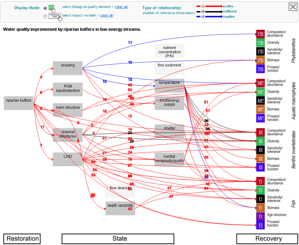
While the development and intercalibration of assessment methods was by far the largest part of WISER, three “work packages” have addressed ecological restoration in rivers, lakes and marine ecosystems. In case of rivers, this exercise started with generating “cause-effect-recovery-chains” by synthesizing literature and expert knowledge (see Figure below). These chains describe how biotic assemblages are supposed to change following degradation and restoration. The chains are provided in an interactive form on http://www.wiser.eu/results/conceptual-models/. The analysis of large data sources, which resulted from monitoring under the WFD, revealed the overarching effect of catchment and riparian land use on river ecological status, while the effects of local hydromorphology are significant but smaller. These results are in line with the approach of the WFD, which asks for river basin management plans and thus moves away from simply restoring small single rivers stretches. This pattern is further supported by the comparative analysis of river restoration effects. Also here, it is apparent that the situation in the catchment largely determines what can be achieved through restoration. And last but not least: recovery of degraded water bodies takes time. Even if stress intensity has successfully been reduced, biotic recovery might take one or two decades.

Figure: Cause-effect-chain describing the effects of riparian buffer establishment of river biota (Note: please scroll to the bottom of the article for a version of the figure where you can zoom to view details)

There are many more results of WISER, which are further described in about 150 publications, also counting those which are in print or in an advanced stage of preparation, and 90 reports with more than 5,000 pages. To reduce these to a digestible amount of information, WISER has produced key messages, which can be found on www.wiser.eu/key-messages. Figure Cause-effect-chain describing the effects of riparian buffer establishment of river biota

For further information: 

Author: Daniel Hering, University of Duisburg-Essen

REFORM Meta analyses – What is it about?

In the 2010 FP7 call for a research project on hydromorphology and ecological objectives of the WFD, the European Commission explicitly requested to make use of existing knowledge and expertise. REFORM has addressed this explicitly in its first and cross-cutting work package. The main aim is to make the state-of-the-art knowledge on hydromorphology, the interaction with ecology and wider environmental aspects timely available to support river basin managers while preparing the next round of River Basin Management Plans (RBMPs). The results will be made available through regular deliverables, but also through the REFORM Wiki. Early 2013 REFORM will organise an interactive stakeholder workshop to support science-policy and science-practice interfacing on hydromorphological degradation and restoration of rivers. The compilation of the existing knowledge in work package 1 will form the basis to discuss the scientific foundation and applicability and further ambitions of REFORM. This start of REFORM will support all subsequent tasks within the project by compiling and providing information on existing knowledge.


Figure Cross-cutting work package 1 synthesizes existing knowledge and expertise on hydromorphological degradation and restoration of rivers. The majority of its output is available early 2013

In more detail we will critically evaluate and analyse existing data (published and unpublished) on:

  1. the linkages between river morphology and their underlying hydro-physics, hydromorphological and ecological variables and processes
  2. the effects of hydromorphological restoration on these variables and processes
  3. the socio-economic drivers and gains of hydromorphological alterations
  4. the socio-economic constraints for, costs and benefits of hydromorphological restoration.

 This review will allow to analyse:

  1. the biotic responses to environmental degradation
  2. the effects of multiple pressures on various temporal and spatial scales
  3. the first RBMPs on a European scale to identify knowledge gaps, develop and sharpen hypotheses

To meet these objectives, work package 1 is broken down into six tasks:

In task 1.1 we review and analyse the existing hydromorphological survey methods comparably to a similar analysis of the biotic assessment methods already performed within the EU project WISER. We hypothesise that existing survey methods are mainly focussed on the site and reach scales and do not sufficiently cover process-based characteristics. Based on the relevant bottlenecks for biota we will identify suggestions for additional metrics and variables will be developed (scheduled to be available by October 2012).

In task 1.2 we review and analyse the effects of pressures on hydromorphological variables and processes based on a typology of pressures developed within the IWRM-NET project FORECASTER. The main objective is identifying the most eco-hydromorphological relevant impacts across spatial and temporal scales (April 2013).

In task 1.3 we review the linkages of a set of core hydromorphological variables and variables describing ecological status and functioning. Response variables will include ecological status as measured by biological quality elements (fish, invertebrates, macrophytes, diatoms) and a set of functional parameters (self purification capacity, aquatic-terrestrial interactions, functional traits) and will be classified according to major physical processes, effect size and response time. We hypothesize that species tolerance thresholds are more relevant for addressing existing limitations for biota compared to habitat preferences (April 2013).

In task 1.4 we analyse the first RBMPs and Programmes of Measures in regard to eco-hydromorphology. It is a highly applied task to immediately provide knowledge for the drafting of the second RBMPs and Programmes of Measures. Gaps in knowledge and application of restoration measures will be identified and potential ecological improvements and drawbacks predicted (April 2013).

In task 1.5 we review and analyse the socio-economic drivers and effects of hydromorphological degradation and restoration, in particular focusing on the costs of hydromorphological degradation and on the definition and development of cost typologies. This task further compiles metadata of existing cost information on hydromorphological degradation (October 2013).

In task 1.6 we will manage the meta-data produced within REFORM. This task will provide data to the other work packages of REFORM.  The meta-database will help making the project results publicly available and providing a knowledge tool for all kinds of stakeholders, especially water managers.

For further information: 

Author: Christian Wolter, IGB

Field training course in Silkeborg, Denmark

European research projects offer the opportunity to collect data over a wide geographical range, which is in most cases not possible for single institutes. On the other hand, any fieldwork performed in EU projects faces the danger of poor comparability, due to differences in sampling and sample processing between institutes. To tackle this problem REFORM scientists organized a field training course for all staff involved into fieldwork. Fieldwork will be performed in a selected number of case studies in Central and Northern Europe. These case studies are presented on the REFORM website (http://www.reformrivers.eu/study-sites). The aim is to compare the dimension of river restoration projects and the interaction within the catchment on the effectiveness of the restoration measure.

The training course was hosted in May 2012 by the Danish REFORM partner, Aarhus University, in a field station close to Silkeborg. Scientists and technicians from Finland, Sweden, Denmark, UK, Germany, The Netherlands, Poland, Czech Republic and Austria participated, i.e. almost all partners involved into field work within REFORM’s Workpackage 4, in which restored and non-restored river stretches will be comparatively analyzed in several European countries. The only country from which no scientists attended was Switzerland, as most of the fieldwork planned there will be performed by some of the above partners.

Photo: Cross-sections for recording river hydromorphology (Picture by Kathrin Januschke)

The training course started with half a day of theory. Background and procedure for all field methods, which will be applied to the study of rivers, were presented and discussed. The range of methods covers a standard hydromorphological survey, transect methods to record habitat composition in the river and its floodplain, the sampling of stable isotopes to analyze food webs and land-water interactions, and the sampling of five organism groups: fish, benthic invertebrates, aquatic macrophytes, floodplain vegetation and riparian ground beetles to cover both longitudinal and lateral components of river-floodplain ecosystems.

The second day was devoted to the practical demonstration and training of the methods in the field. For this purpose, the participants visited the two rivers, which will be studied by the Danish project partner in REFORM: the Stora and the Skjern. Along the Stora a relatively small stretch was restored, mainly by adding gravel as a spawning ground for salmonids; the Skjern catchment hosts one of Europe’s largest river restoration projects, where the whole floodplain was included over a length of several kilometers. Weather conditions turned out to be realistic for fieldwork in Northern Europe; for most of the day the rain felt horizontal due to strong wind. However, the training effect was particularly high, as all participants will remember this field work vividly. And it showed that the methods are applicable even under adverse weather conditions.

Photo: Periphyton and macroinvertebrate sampling for stable isotope analysis (Picture by Kathrin Januschke)

The workshop closed with half a day of discussion about the methods. This led to some adaptations, in particular of the method for recording floodplain vegetation. Following the meeting the protocols describing the methods were adapted, are now ready for use and available as one of the first deliverables of the project.

Overall, it was a successful and intense meeting, which was scheduled in an ideal way directly before the fieldwork – which is starting in June 2012. The hydromorphological methods and the stable isotope sampling will now be applied to almost all study rivers, while the sampling of the biological variables will partly be performed in 2012 and partly in 2013.

For further information: 

Author: Daniel Hering, University of Duisburg-Essen

The River Narew (Poland) has it all being in part natural, regulated and restored

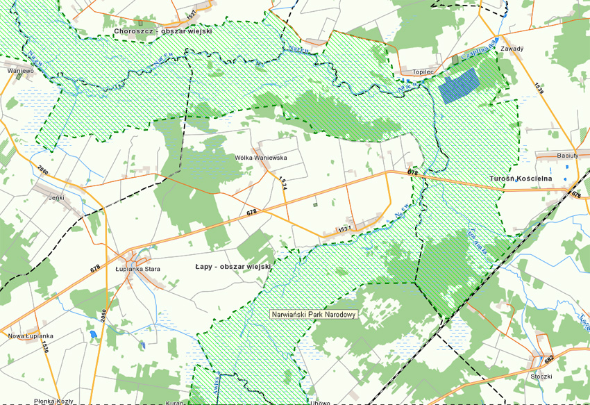
In the past the River Narew (Poland) split into multiple, interconnected, coexisting channel belts, thus creating numerous backwaters and oxbows. Such river systems situated on alluvial plains are referred to as ‘anastomosing’ in scientific literature. They distinguish themselves by a dense network of belts of variable width and length which by turns split and join. The hydrological regime of the River Narew manifested itself by long lasting flooding and additional intensive inundation by shallow groundwater.

Photo: Grasslands in the regulated section of Narew (Tomasz Okruszko)

In the late 1970s, a reach of the River Narew between the village of Kolonia Rzędziany and the junction with the Biebrza River has been engineered. As a result, the network of multiple channel belts was replaced by one deep channel. The grasslands and meadows replaced the wetland ecosystems. Contrarily, the upstream part of the Narew River still consists of multi-channel riparian wetlands which in 1996 became a protected area called the Narew National Park (NNP; www.npn.pl). However, hydrological alterations in the regulated stretch led to the decrease of the groundwater level in the NNP favouring common reed expansion and shrubs encroachment causing a loss of ecosystem biodiversity.

In the early 1990s, the Polish Bird Protection Association (PTOP) initiated a project focused on restoration of partly natural conditions in a so called buffer zone i.e. between the park and intensive grasslands. First restoration works began in 1996 on the oxbows near the village of Rogowo. In the period 1996-2001 the oxbow lakes were cleared and the shrubs, mud deposits, reeds and their parts were removed. The next step was the construction of new river channels through the Rzędziany-Pańki dike (which is the border between park and grasslands) aiming to restore the multi-channel system. The first of two stone rapids in the main artificial channel was constructed in 2007 and the second was finished in 2010. The aim is to increase the water level in the downstream part of the park.  Farmers in the surrounding area have strongly protested against the construction of rapids. The area exposed to restoration works is situated in the northern part of the NATURA 2000 PLB200001 site called Bagienna Dolina Narwi (the Wetland Narew Valley) stretching between the villages of Kolonia Radule and Żółtki and covering ca. 13.4 km2. This area is located on the downstream border of the Narew National Park.

Photo: Rapid increase of the water level in the buffer zone  (Tomasz  Okruszko)

The Narew National Park was founded in 1 July 1996. It is situated in the north east of Poland, in Podlasie Province, 30 km west from its capital, the city of Białystok. Its headquarters is located in the village of Kurowo. The Park covers 6,810 ha of the Narew 45 km long valley bottom between the villages of Suraż and Rzędziany. Within the NNP 98% of soils are permanently or temporarily inundated. The objective of the Park is to protect the wetland valley covered by alder carr, sedge and sedge-moss meadows.

The Narew River is one of the case studies of REFORM aiming to assess the interaction between restored stretches and the status of the wider catchment.

For further information: 

Author: Tomasz Okruszko, Warsaw University of Life Sciences
Author: Anna Wróblewska, Warsaw University of Life Sciences

11th Meeting of Working Group F on Floods of the WFD Common Implementation Strategy (Bucharest, 19 April 2012)

On 19 April 2012, the Working Group F on Floods of the WFD Common Implementation Strategy (CIS) held its 11th meeting in Bucharest (Romania). The aims of the meeting were to discuss the current status of the Floods Directive reporting (including the Floods Directive Viewer) and to plan the next steps to be adopted after the recent completion of the preliminary flood risk assessment. During the meeting, an update on related research activities and events (e.g. 2nd ERA-Net CRUE Funding Initiative, REFORM project, UNESCO-IOC website on Tsunamis, FLOODrisk 2012 Conference) and on related EU activities (e.g. public consultation for the Blueprint, the 2013-2015 Working Group Work Programme and the EU Flood Impact database) was provided.

On the Floods Directive implementation, three of the main issues addressed by Working Group F were: firstly, the pilot study and testing phase for the flood hazard and flood risk map reporting (currently ongoing – joined by CZ, DE, IE, IT, NL, SE and UK); secondly, the realization of a resource document aimed at ensuring an effective coordination of the Floods Directive and the WFD; lastly, the outcomes of the most recent Thematic Workshops of Working Group F (“Floods and economics”, Oct. 2010, Ghent, BE; “Stakeholder involvement in flood risk management”, Apr. 2012, Bucharest, RO). The European Commission recalled to Working Group F delegates to start consulting the national colleagues involved in the WFD implementation in order to coordinate the first cycle of the Flood Risk Management Plans and the second cycle of the River Basin Management Plans.

In this context, Dr. Stefano Mariani (ISPRA, IT) introduced the REFORM project to delegates present at this meeting of Working Group F on Floods. REFORM aims indeed to have a practical and, potentially, EU-wide impact on river basin management planning policy, by developing instruments and guidelines for successful and cost-effective river restoration and by improving procedures to monitor the biological responses to hydromorphological change, in the context of policy integration.

The linkage between REFORM and Working Group F on Floods is considered particularly useful to enforce the synergy between the tools and guidelines on ecological river restoration, as planned by REFORM, and the flood protection measures, as required by the Floods Directive.

The presentation on REFORM gave details on the different work packages of the project, the REFORM case study areas and the project’s dissemination plans including plans for a “River Restoration Wiki” (an interactive tool for presenting information and results of the case-study activity).

Dr. Mark Adamson (Office Public Works, IE), the Working Group F co-chair, expressed interest in REFORM and showed the group’s willingness to be kept informed on project future activities and be updated on project results.


Figure: Schematic representation of the main elements of the REFORM dissemination strategy

More information on this meeting is available at 

http://circa.europa.eu/Public/irc/env/wfd/library?l=/framework_directive...

For further information: 

Author: Stefano Mariani, Ispra

ECOSTAT workshop on Hydromorphology of the WFD Common Implementation Strategy (Brussels, 12-13 June 2012)

On 12 and 13 June 2012, around 90 people participated in the ECOSTAT workshop on hydromorphology in Brussels. Already for a number of years ECOSTAT supports EU Member States with issues related to intercalibration and ecological classification for the implementation of the Water Framework Directive (WFD). In December 2010, the Water Directors asked Working Group A Ecological Status ("Ecostat") to provide advice on the potential to intercalibrate good ecological potential. For this a workshop has been organised.

This workshop intended to contribute to an understanding of the current state of play with respect to the assessment of hydromorphological impacts and the classification of ecological potential. The focus was on methods that are already in use in the Member States or other European countries. Target groups were technical experts and practitioners. Most of the EU Member States were represented as well as representatives from DG Environment and various stakeholder groups (e.g. NGOs, hydropower, navigation). The presentations covered methods predominantly for rivers, but also for lakes, estuaries and coastal waters. The presentations were organised in four sessions:

  1. Hydromorphological assessment methods
  2. Ecological assessment methods
  3. Methods for assessing ecological potential in heavily modified and artificial water bodies
  4. Environmental flows in rivers affected by impoundments

The organisers will compile this first EU wide overview of methods and prepare a proposal how to proceed. The REFORM project was invited to present its aims and approach including a glimpse of one of the first draft results on hydromorphological assessment methods. Both members of ECOSTAT and REFORM are in favour of organising a joint meeting early 2013 in Brussels where the follow-up of this workshop will be combined with the first results of REFORM. We will inform you through our website and future newsletters when more details are available.

For further information on the ECOSTAT workshop on hydromorphology please contact Wouter van de Bund (JRC) or Peter Pollard (SEPA).

For further information: 

Author: Tom Buijse
Wouter van de Bund, JRC
Peter Pollard, SEPA